HIGHESCALATION
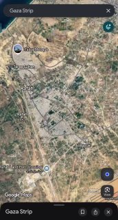
Google Maps updated its default satellite imagery for Gaza to January-February 2026 captures, making the scale of destruction immediately visible to anyone opening the app.
🌍 GLOBALSep 28, 2026 10:25SRC: CLASH REPORT
INTELLIGENCE SUMMARY
Google Maps updated its default satellite imagery for Gaza to January-February 2026 captures, making the scale of destruction immediately visible to anyone opening the app. The 2026 tiles show dense residential blocks in Rafah and Khan Younis reduced to gray rubble fields, Al-Shifa Hospital area heavily altered, and massive tent camps on remaining open ground. UNOSAT's latest count: 201,290 damaged structures (82% of all buildings), 134,422 destroyed. The imagery covers ~235 km² at ~13 cm r
AI THREAT SCORE70/100